Do you work on maps? If so, this free addon may suit your needs
ZWGis is an application for user, who work on maps and reqiure access to geospatial information in their project. With this addon, you can load various GIS formats.

► Introduction
ZWGis is a free application for ZWCAD, that enables loading WFS, SHP and GML files, as well as to manage them in a simple way. You can also download OpenStreetMap rasters via the application.
ZWGis is a part of ZWGeo addon, where all these funcions are present and more advanced. If you need more tools than ZWGis offers, you can try ZWGeo.
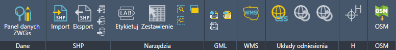
► Ribbon and toolbars
ZWGis ribbon:
ZWGis toolbar:
![]()
► General Information
- Version: 2026
- Languages: English, Polish
- Category: Surveying
- Industry: Surveying
- Required application: ZWCAD 2026 Professional
- Operating Systems: Windows
- Licence type: Free
- Price: -
Download ZWGis!
ZWGis 2026
► Key Features
Functionality of the ZWGis application:
- Data - this function allows you to view information assigned to drawing objects (created, for example, after importing an SHP file),
- SHP import,
- GML import,
- WMS - loading maps from gov.pl servers,
- CSS - setting the geodetic datum,
- Filling and filtering,
- OSM - inserting raster maps from the Open Street Map server into the drawing.
Icons in grey are inactive in ZWGis. The functionality is only available in the commercial ZWGeo application.
► Links
-
Product instruction:
-
The software necessary for addon's usage:
► Add-ons Publisher
- Company: IT Solutions SZANSA
- Company Website: http://www.zwcad.pl
- Product Website: https://cadextender.com/
- Email: This email address is being protected from spambots. You need JavaScript enabled to view it.